Last reviewed: September 23, 2026.
Every house I ever worked on had a story its owner could not tell me. A bedroom off the back of a 1920s bungalow with a floor two inches lower than the rest of the house. A garage with a service panel far too big for a garage. A downspout that vanished into the lawn and came out nowhere. The owners had lived there fifteen years and had no idea, because nobody ever handed them the paperwork — and in Seattle there is a lot of paperwork. Permits have been issued here since 1894, the county has photographed and priced the building every year for decades, and the City still holds a hand-drawn card showing where your side sewer runs.
Almost all of it is public. Almost all of it is free. It is just scattered across five or six systems that do not talk to each other, two of which are only discoverable if you already know they exist. This is the map: what is on the record, which portal holds it, what each one will not tell you, and how to answer the four questions people actually ask — who owned it, when was it built, was that work permitted, and what is buried in the yard.
- Owners and prices come from the King County Assessor's sales list; the deed image comes from the Recorder, by recording number.
- Year built is the Assessor's number, not a permit. On an old house, trust the permit record over it.
- Permits live in two places: the City's open data for the modern ones, and scanned microfilm for 1894–1970.
- Approved construction plans from 2007 on are not online at all — they take a written request to SDCI's microfilm library.
- Buried tanks show up only if someone pulled a decommissioning permit; those records begin in 1996, and absence is not proof.
What is actually on the record
It helps to know what kind of record you are hunting before you open a portal, because the systems are organized by who created the paper, not by what you want to know.
The county values your house. The Assessor re-appraises every parcel annually, and the record it keeps is startlingly detailed: lot size, zoning, easements flag, water source, sewer versus septic, the building's year built, stories, finished area floor by floor, bedrooms, baths, heat source, grade, condition, a decade-spanning tax roll, every sale it has processed, a current photo, and a floor-plan sketch of the footprint.
The county records your documents. Deeds, deeds of trust, plats and short plats, easements, covenants and liens are recorded with the Recorder's Office and get a recording number. That number is the key to the whole chain: without it, the search itself is gated.
The City permits your work. Every permit — construction, demolition, land use, electrical, plumbing, mechanical, side sewer, furnace, sign — creates a record with a description, a status, a valuation and dates. Since the digital era those are in open data; before it, they are on microfilm.
The utilities draw your connections. Seattle Public Utilities keeps a scanned side-sewer card for most parcels: the as-built route from the house to the main, the connection point, and on the older cards the depths and materials. City Light and SPU also hold water-service records with install years and pipe material.
The state tracks contamination. Ecology's cleanup, underground-storage-tank and environmental-covenant lists are exported wholesale, and the Fire Department's residential tank permits are in City open data.
Dates are the published start of each collection, not a promise that your parcel appears in all of them. Sources: SDCI Permit & Site History (microfilm 1894–1970), King County Parcel Viewer historical imagery, WA State Digital Archives property record cards, King County Recorder, City of Seattle open data.
The records dossier queries the sources it can reach programmatically for one address — the assessor parcel and tax roll, sales with their recording numbers, permits including the microfilm where SDCI holds it, tanks, hazards, side-sewer and water cards — names the source of every line, and lists the ones that need a written request so you can pull them yourself.
The free sources, and what each one will not tell you
Here is the honest table. I have marked each row the way our reports do: ★ for an official record you can cite, ◇ for something that is an estimate or an inference — useful, but not evidence.
| Source | What it gives you | What it will not tell you |
|---|---|---|
| ★ King County Assessor, eReal Property | Parcel and legal description, lot size, zoning, easement flag, water and sewer/septic, year built, finished area, beds and baths, heat source, the tax roll year by year, every sale with its recording number, a current photo and a footprint sketch. | No tank, well or septic record. No historical photos — one current image only. Sales it never processed. And its year built is a valuation fact, not a permit. |
| ★ King County Recorder (Landmark Web) | The scanned document itself — deed, easement, covenant, plat — retrieved by recording number with no login. | Searching by parcel, name or legal description is reCAPTCHA-gated, so you need the number first. Online images effectively start in 1991; earlier documents are at King County Archives. Some numbers simply fail to resolve. |
| ★ SDCI Permit & Site History | Every permit record on the development site, plus scanned documents by address: Historical Microfilm Permits 1894–1970, legal descriptions, record snapshots, site plans, checklists and certificates. | Approved construction plan sets from roughly 2007 on are not listed. SDCI says access to approved plans requires an individually written request to its microfilm library. |
| ★ City of Seattle open data | Modern building, electrical and trade permits with status, valuation, plan-review days and cycles; code complaints and violations; rental registrations; and the Fire Department's residential oil-tank decommissioning permits. | Nothing from the paper era. Complaint records are address-matched, so a neighbor's file can look like yours. A tank never decommissioned under a permit produces no row at all. |
| ★ SPU side sewer card viewer | The scanned as-built card: the route from the house to the main, the connection point, and on older cards the depth and pipe material. | It is a drawing made on the day of the work, not a survey, and not every parcel has a card. It does not tell you the pipe's condition — that is a camera job. |
| ★ WA State Digital Archives | Assessor "Real Property Record Cards" — the 1930s–40s tax cards, which include a photograph of the building as it stood then. | A search interface, not a feed. Coverage and legibility vary, and the card describes the building, not the title. |
| ★ King County historical aerials | Your lot from above in 1936, and then in most years from 2007 on — outbuildings that came and went, the driveway before it was paved, the tree that used to be there. | Resolution on the old frames is coarse. King County's orthophotos also carry vendor terms that restrict resale, so you can view them but not republish them. |
| ★ Ecology cleanup, UST and covenant lists | State-tracked contamination, leaking-tank sites, no-further-action determinations and environmental covenants, exported in full. | Site-level, not parcel-level, matching. A clean result means "not on the state's list", which is not the same as clean soil. |
| ◇ What you conclude from all of it | A story: the addition that explains the odd floor level, the panel upgrade that dates the wiring, the sewer that runs the wrong way. | Any of it being evidence. An inference from records is a lead for a professional, not a finding — which is why the marker is a diamond. |
★ official or measured record · ◇ estimated, modeled or inferred. It is the same convention every figure in our reports carries.
How to check whether work was permitted
This is the question that costs people money, usually three days before closing. The sequence I would follow:
-
Write down what you are asking about
A bathroom, a basement bedroom, a garage conversion, a deck, a new panel, a furnace. Be specific: permits are indexed by work type, and "the basement" is not a work type.
-
Search the address in SDCI's Permit & Site History tool
It returns every record on the development site — including pre-applications, withdrawn records and rental registrations — and a document index you can download from, by address.
-
Download the Historical Microfilm Permit for the address
On a pre-war house this single scanned PDF is usually the whole story: the original permit, the additions, the re-roofs, in one file. It is the only evidence that a 1950s addition was ever legal.
-
Cross-check the open-data permit sets
Building, electrical and trade permits are separate datasets. A finished basement with a building permit and no electrical permit is a different problem from one with neither.
-
Check the complaints dataset too
Code complaints and violations are public. An old complaint that was resolved tells you the City has already looked at the house, and what it looked at.
-
If you need the drawings, ask in writing
Approved plan sets from about 2007 on are not published. SDCI's microfilm library takes an individually written request — and that is the part you cannot do in an afternoon.
No permit on the record is a gap, not a verdict. Paper was lost, addresses were renumbered, and plenty of work never needed a permit in the first place. What the gap does mean is that you are the one who now has to explain it — to a buyer, an appraiser, or an inspector.
The oil tank, the shared sewer, and the other things that surface late
Three items account for most of the "nobody told me" moments I have watched on Seattle sales.
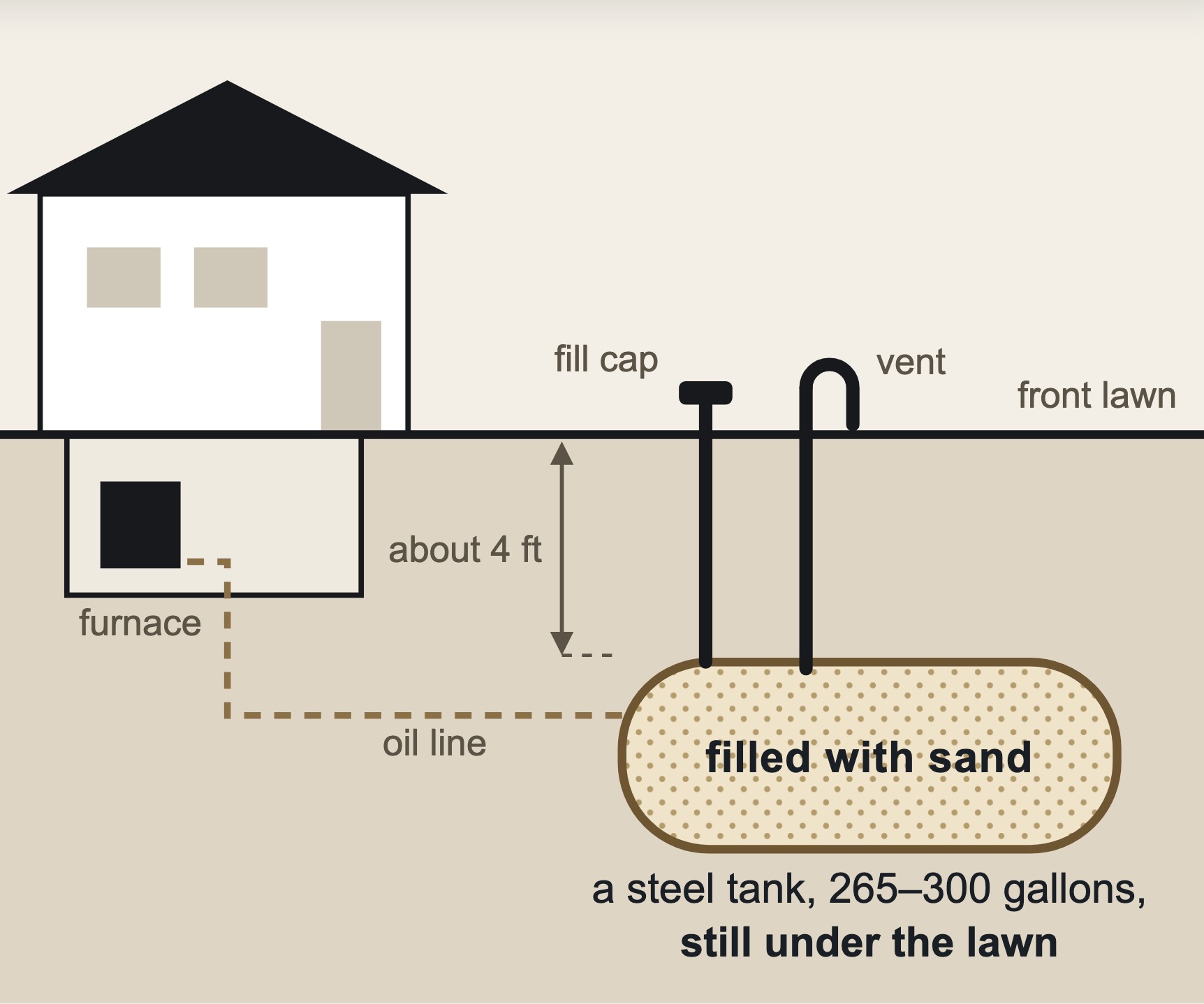
The heating-oil tank. Thousands of Seattle houses were heated with oil, and the tank usually stayed in the ground. The Fire Department's residential underground storage tank dataset lists decommissioning permits with the tank's size, its contents, the decommissioning date, and the method — removal, or abandonment in place, which means the tank is still there, cleaned and filled. That distinction matters to a buyer and to a lender, and it is free to look up. What the dataset cannot tell you is whether a tank nobody ever permitted is sitting under the side yard. For that, the Assessor's heat-source field is a hint and a tank sweep is the answer.
The side sewer. Seattle has a lot of shared and cross-lot side sewers, particularly in the older plats where one line was laid to serve two houses. The scanned side-sewer card is where you find out, and it is the same card that decides what a backyard cottage costs to connect — a shared line, or one running under a neighbor's driveway, is a budget reset, not a paperwork one. The same logic runs the other way on lots that back onto a platted alley, where the main is often right there.
The easement nobody mentions. The Assessor's land record carries a yes/no easement flag. The easement document is at the Recorder, under a recording number, and it is the thing that quietly decides where you may build. If the flag says yes and nobody can produce the document, that is the afternoon's real task.
What an afternoon of portal-hopping gets you, and what it does not
Everything above is genuinely free, and if you enjoy this sort of thing you will find it satisfying. I want to be straight about where it stops, because that is the only honest case for paying anyone.
What an afternoon does not give you is the assembly. The Assessor's sales list gives you recording numbers, but you fetch each deed yourself, one number at a time. The permit tool gives you a document index, but you download each scan yourself. The tank dataset needs an address-pattern search, not an address. The side-sewer card is keyed to the parcel number, which you have to get first. None of it lands in one place, nothing is dated as of the day you looked, and there is no list of what you failed to find — which is the part that bites, because a record you never knew existed is indistinguishable from a record that does not exist.
That is what the Seattle Property Records Dossier does: it runs the machine-readable part of this list for one address and prints the result, with every figure attributed to the agency that issued it. On the published sample — the owner's own house in Licton Springs, address withheld — it came back with 42 records across 12 County and City sources, 11 documents attached in full, organized into 17 content chapters over 22 pages. The last chapter is the one I would not skip: it names every source that could not be retrieved, the department to request it from, and the record numbers to cite — the three known handoffs being approved plan sets, the live tax balance behind its captcha, and septic records.
The honest limit: scanned records are attached in full up to 6 scanned pages per source, and the attached set as a whole stays under 3.8 MB so the PDF stays emailable. A longer document keeps its first pages and the remainder is listed in the appendix as “N of M pages embedded” with its public-record URL, so nothing disappears quietly — you can always pull the rest yourself.
And the limits that are not about file size: it is not a title report, not title insurance, not a legal opinion, and not an inspection. It cannot find a lien or an easement that is not in the records we query. If you are buying, it belongs next to a title commitment and an inspector, not instead of them.
Owners and deeds, every permit we can retrieve — including any 1894–1970 microfilm scans SDCI holds for your address — tanks and hazards, the side-sewer and water cards, and the historical aerials that cover your parcel. One sourced PDF, with the documents attached and every source we could not reach named in the last chapter.
When the paper trail is really a feasibility question
Sometimes people come to the records with a different question underneath: not "what happened here", but "what can I do here". Those are different jobs, and it is worth knowing which one you are on.
The paper trail is about the house that exists. If what you actually want to know is whether a backyard cottage fits behind it, the record you need is the lot — the surveyed setbacks, the buildable rectangle, the trees, the slope, the sewer capacity. The permit history matters there too, but only as an input: the citywide median for a Seattle detached accessory dwelling unit permit runs 138 days from application to issuance, measured across 1,062 permits issued since 2024, and the files that take longest are usually the ones where something on the lot was never looked up. The Seattle DADU permit guide walks that process, and the customized feasibility report ($149) measures the lot itself.
And if the reason you are reading the record is a number on a valuation notice, the Assessor's own sales data is the raw material for an appeal — the King County property tax appeal guide covers the deadline and the comps that carry it.
"The house will tell you what happened if you can read its paperwork. Every strange floor level, every oversized panel, every drain that goes nowhere had a permit or didn't, and either answer is worth knowing before you sign something."
— Bob Hall, retired Seattle builderFrequently asked questions
How do I find out who owned my house in Seattle?
Start at the King County Assessor's eReal Property record for your parcel. Its Sales section lists every sale the county has processed — date, price, instrument type, seller, buyer, and the recording number. Take the recording number to the Recorder's Landmark Web viewer, which returns the scanned deed with no login. Searching the Recorder by parcel or name is captcha-gated, so you need those numbers first, and online images effectively begin in 1991; earlier deeds are held by King County Archives.
How do I find out when my house was built in Seattle?
The Assessor's building record carries a year built, plus finished area, beds, baths, heat source and grade. Treat it as the county's valuation fact rather than proof: on older houses it can disagree with the permit record. The scanned 1894–1970 microfilm permits are the older evidence, and the Washington State Digital Archives holds 1930s–40s assessor property record cards that include a photograph of the building.
How can I check whether work on a Seattle house was permitted?
Search the address in SDCI's Permit & Site History Research Tool, download the Historical Microfilm Permit if the house predates 1970, then cross-check the City's building, electrical and trade permit datasets. Work that exists in the house with no permit on the record is a gap you will have to explain — but an absent record is not proof of an unpermitted job, because old paper was lost and some work never needed a permit.
How do I find out if there is a buried oil tank in my Seattle yard?
Two free checks. The Seattle Fire Department's residential underground storage tank records on the City's open-data portal list heating-oil decommissioning permits with tank size, contents, date and method — removal or abandonment in place — and those records begin in 1996. The Assessor's heat-source field is the second hint: oil heat on an old house means a tank existed somewhere. Neither proves absence, which is why buyers order a tank sweep.
Is a property records dossier the same as a title report?
No. A title report is a title company's examination of the chain of title, with insurance behind it. A dossier is every public record we can retrieve, organized, sourced and attached. It will not find a lien, claim or easement that is not in the records we query, and it is not a legal opinion or an inspection. Confirm anything you will rely on with the issuing agency or a title company.
Sources
- King County Assessor, eReal Property parcel detail (parcel, land, building, tax roll, sales with recording numbers, permit log) — blue.kingcounty.com.
- King County Recorder's Office, Landmark Web document search and document images — recordsearch.kingcounty.gov; pre-1991 documents via King County Archives.
- SDCI Permit & Site History Research Tool, including Historical Microfilm Permits 1894–1970 — maps.seattle.gov/sdcipermithistory.
- SDCI, researching a project and requesting approved construction plans (written request to the microfilm library) — seattle.gov/sdci.
- City of Seattle open data: building, electrical and trade permits; code complaints and violations; rental property registration; Underground Storage Tank Records – Residential (records begin 1996) — data.seattle.gov.
- Seattle Public Utilities side sewer card viewer — maps.seattle.gov/sidesewercardviewer.
- Seattle Municipal Archives, "Resources for Property History Research" — seattle.gov/city-archives.
- Washington State Digital Archives, "Real Property Record Cards" (1930s–40s assessor photo cards) — digitalarchives.wa.gov.
- King County Parcel Viewer historical aerial imagery (1936, then most years from 2007) — gismaps.kingcounty.gov.
- Washington Department of Ecology cleanup, UST/LUST and environmental-covenant lists — apps.ecology.wa.gov.
- Seattle DADU permit timing: 1,062 detached accessory dwelling unit permits issued since 2024, median 138 days application to issue (measured 2026-09-22 from the SDCI permit records).
If you would rather not run the list yourself, the Seattle house history and property records page shows what the assembled version looks like, chapter by chapter, with the sample you can read before you buy. If your question is about what you can build rather than what was built, start with the free can I build a DADU checklist or the Seattle DADU Pro Guide.
This article is educational and preliminary. It is not legal advice, title advice, tax advice, or an inspection, and it is not a title report or a title insurance commitment. We are not attorneys, title examiners, appraisers, or licensed inspectors. Public records are incomplete, and a record's absence is not proof that something did not happen. Portals, datasets, and request procedures change — verify everything against current City of Seattle, King County, and Washington State sources before you rely on it, and consult qualified professionals before making purchase, disclosure, or construction decisions.