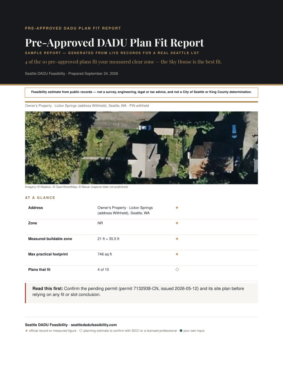
Pre-Approved DADU Plan Fit Report

Which Seattle pre-approved DADU plans fit your lot — measured, not guessed.

Run the City of Seattle's ten pre-approved DADU plans against your lot's measured buildable zone and get a plan-by-plan FITS / FITS ROTATED / DOESN'T FIT matrix, the eligibility gates that can remove the pre-approved path, and the tree interference that could shift a footprint — before you pay a designer.

$49 one-time · 18-page sample · In minutes

PDF by email in minutes · Stripe-secured · you confirm the matched parcel before you pay

Photo: Sky House pre-approved DADU plan — Yes Architecture — via City of Seattle ADUniverse

Try it

Which plans fit your clear zone?

Enter the width and depth of your buildable rectangle. We screen all 10 published footprints in both orientations, with a 2 ft tolerance.

Get the measured answer for your lot

Inside this dossier

A 18-page sample, chapter by chapter.

The chapter index of your report — the real table of contents from the sample, rebuilt for your address at purchase.

  1. Cover1
  2. Report disclaimer2
  3. Your property from above5
  4. Executive summary6
  5. Your clear zone, measured6
  6. Which plans fit7
  7. The plans that fit, in detail8
  8. Eligibility gates10
  9. Trees on the lot10
  10. Permit path & timeline11
  11. What would change this verdict11
  12. Worked examples from real Seattle lots14
  13. What to do next15
  14. Sources16
  15. Before you rely on this3
  16. Next step: the full study18

Sample pages

How it reads, page by page.

Plan-by-plan fit matrix — three pages from the sample PDF, generated from a real Seattle address. Your copy is built from your own parcel.

Method & sources

Methodology: where every figure comes from.

Every figure follows the same methodology — live public records or a dated constant, marked ★ official or ◇ estimate.

  • City of Seattle pre-approved DADU gallery (ADUniverse)10 published plans — footprints, designers, floor areas (2026-09-16)
  • Seattle building outlines 2023 + parcel boundariesused to measure the buildable rectangle
  • SDCI zoning, overlays and critical areasNR-zone and ECA eligibility gates
  • Seattle tree canopy LiDAR 2021crown radii and estimated tiers
  • SDCI residential permit recordspermit path and measured timing

Worked examples

Real Seattle lots, run through this report.

Three Seattle addresses measured with the same engine, so you can see how the analysis lands on lots like yours.

Licton Springs — Fit unconfirmed — a unit is already under construction
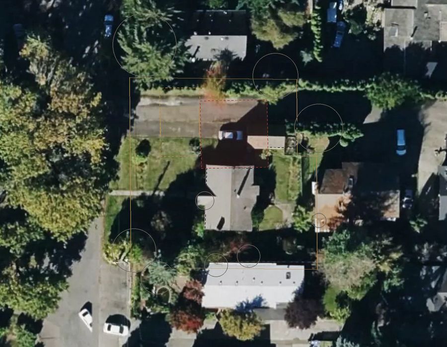
Aerial with the report's measured overlays drawn to scale.

Worked example 1 · Licton Springs

Fit unconfirmed — a unit is already under construction

Zone
NR
Measured buildable zone
21 ft × 35.5 ft
Max practical footprint
746 sq ft
Plans that fit
4 of 10
Best fit
Sky House

On this Licton Springs lot the measured buildable zone is 21 ft × 35.5 ft — about 746 sq ft in the north side yard, beside the house, once setbacks and separation are applied. But a detached unit is already under construction here, and the zone was measured from outlines and imagery that predate it, so the "how many plans fit" screen is unconfirmed until the unit's as-built footprint is located. Unit already under construction. The NR zoning and the pre-approved path still apply, but confirm what is being built before shopping the catalog, then order a boundary survey to pin the lot lines.
Ballard — 8 of 10 pre-approved plans fit
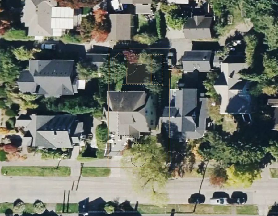
Aerial with the report's measured overlays drawn to scale.

Worked example 2 · Ballard

8 of 10 pre-approved plans fit

Zone
NR
Measured buildable zone
25 ft × 40 ft
Max practical footprint
1,000 sq ft
Plans that fit
8 of 10
Best fit
Schooner

On this Ballard lot the clear zone measures 25 ft × 40 ft — about 1,000 sq ft — and 8 of the 10 published pre-approved plans fit it with at least 2 ft to spare — the best is the Schooner. The rest do not make it, so the stock catalog is not a free pass, but a short list still works. Max practical footprint is about 1,000 sq ft. It is an NR zone with no critical area, so the pre-approved path stays open. Confirm the exact footprint with the designer and order a boundary survey before spending on design.

Ballard — No pre-approved plan fits
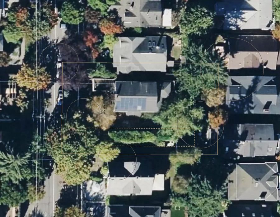
Aerial with the report's measured overlays drawn to scale.

Worked example 3 · Ballard

No pre-approved plan fits

Zone
NR
Measured buildable zone
71.5 ft × 11.5 ft
Max practical footprint
0 sq ft
Plans that fit
0 of 10
Best fit
None

On this Ballard lot the measured clear zone is a 71.5 ft × 11.5 ft sliver — about 822 sq ft of ground, but only 11.5 ft across — and none of the 10 published pre-approved plans fits it: no pre-approved plan is narrower than 14.7 ft, so the practical footprint is 0 sq ft. The stock catalog is not the shortcut here; a custom or modified plan, an attached ADU, or a conversion of the existing house is the realistic path. It is an NR zone, so the zoning is fine — the geometry is the blocker. Before any design spend, order a boundary survey, because a lot line that moves by even two feet can change a sliver into something workable.

Questions, answered

Before you order.

How many pre-approved plans are there?

Ten in the City's ADUniverse gallery, from ten design firms. The report tests every one against your measured buildable rectangle, in both orientations, and tells you the best fit with its clearance margin.

What does 'fits' actually mean?

It means the plan's published footprint is no larger than your measured buildable rectangle in at least one orientation, with at least 2 ft of clearance (under 2 ft needs a survey). It is a geometric screen only — not a permit determination — and the exact dimensions must still be confirmed with the plan's designer and SDCI.

Do I still need a designer if a plan fits?

Yes. Pre-approved plans still get adapted to your site (foundation, trees, utilities, access), and you need a licensed professional for the actual design work. This report tells you which starting point is realistic before you spend on that.

Read first — free

The free Seattle guides behind this report.

Everything this report measures is explained for free first. Read the guide, decide whether you still want it measured for your own address.

Step 1 of 3

Tell us about your lot

Pay on Stripe at step 3
Photos of your house and yard Optional — up to 5, JPEG/PNG
  • Stripe-secured
  • Delivered in minutes

Need the full picture?

This report answers one question. The $149 Customized Feasibility Report covers zoning, setbacks, trees, critical areas, utilities, fees and a permit path — reviewed by a person before it reaches you.

Get the report — $49 All reports